The Hermitage Foreshore Walk, Sydney


Distance: 7kms
Difficulty: Easy, mostly flat.
Good for kids: Yes
Time to walk: 3-4 hours, with stops
Where to eat/fill up your water bottle: The Nielsen, Watsons Bay Hotel, Camp Cove Kiosk
Public Transport: At the end of the walk, if you’re taking a public transport home from Watsons Bay or back to your car parked at the beginning in Vaucluse, you can get on a bus at the Military Road terminal in Watsons Bay. Bus numbers 325 and 380 leave from here regularly. You can also take a ferry from Watsons Bay directly back into the city to Circular Quay.

Not many metropolises are so naturally abundant with open spaces, forest-like parks, coastal walks, and beaches in the heart of the city as they are in Sydney. Exploring on foot is the best way to see it. But if you only ever do one hike here, The Hermitage Foreshore Walk has it all. It offers a side of the Eastern Suburbs of Sydney that most people have never seen before. Grand old houses meet lush bush, calm water, endless swimming opportunities, and a new city view around every corner. It’s uncrowded and relaxed, and despite the blue-chip surrounds, it is delightfully unpretentious.
This trail officially runs from Bayview Hill Road in Vaucluse to Nielsen Park, but an extended version goes all the way to Watsons Bay and further on to South Head. The full walk is about 4.3 miles (7 kilometres) one way, though it can be done in parts. Allow a few hours for swims, snack stops and drinks along the way.

START - Bayview Road to Milk Beach
1 km
If you’re driving, leave your car parked around New South Head Road and weave down through Vaucluse to the end of Bayview Hill Road, where the track starts. This stretch of coast will impress even the most jaded Sydneysider and is filled with cracking views over to Shark Island, Fort Denison and all of Sydney Harbour’s famous landmarks. Milk Beach is an ideal stop for your first swim. A small 50-metre stretch of sand in Sydney Harbour National Park, this shallow bay features rocky overhangs that act as sun shade, and some of the best water views. The secluded beach sits right below Heritage listed Strickland House, a cream-coloured estate with flawlessly manicured gardens.

Milk Beach to Neilsen Park
1.2 km
After a dip, rise back up to the trail between Milk Beach and Nielsen Park, which winds around craggy sandstone cliffs. Inhale the scent of eucalypts and red gums, and keep your eyes open for native flannel flowers and blueberry ash. There’s rumour of a jump rock here from which people plunge 20 feet (six metres) into the harbour below. Around the corner is Nielsen Park and Shark Beach. It’s one of the bigger bays along this walk, and features a verdant, tree-lined public park, a sunlit restaurant (The Nielsen), an enclosed swimming area, and public restrooms and outdoor showers. At the north end, take the path that hugs the coast, rather than continuing along the road.

Neilsen Park to Parsley Bay
1.9 kms
This section of the walk is mostly through the residential backstreets of Vaucluse and is an opportunity to snoop around the mansion-lined streets of this well-to-do enclave. The signage to Parlsey Bay (a tree-shrouded U-shaped bay) is rather discreet, so keep an eye out for a narrow laneway on the left-hand of the road. The path drops down between houses to the iconic white footbridge that hangs over the bay. This is an idyllic spot for a picnic and a swim at the small wharf entry point. Follow the honey-colour rocks around to the spot where you will see others slipping into the water. Then dry yourself in the sun and you drink in the salty air.

Parsley Bay to Watsons Bay
1.5 km
Exit Parlsey Bay up the stairs near the small jetty and walk along The Crescent, to Hopetoun Avenue and then Palmerston Street to get to Gibson’s Beach Reserve (the south end of Watsons Bay). Continue north along the foreshore towards the enormous Moreton Bay fig trees, stopping in for a coffee and cake at the Tea Gardens, next to Sydney’s best waterfront Library (Watsons Bay Library). Or for a refreshing ale in the sun, grab an outdoor table on the deck at Watsons Bay Hotel. You deserve it.

BONUS: Watsons Bay to Camp Cove
1 km
Watsons Bay may be the end of the walk for some, but if you’re wanting more (an extra mile) continue along the beach on Marine Parade towards Camp Cove Beach. Weave through the streets of historic old miners cottages, turned tightly held real estate, and down to the water. Sitting right at the mouth of the Sydney Harbour, Camp Cove is a protected, glassy cove with some of the cleanest water in the city. At the far end, a laid-back beach kiosk serves coffee, orange juice, and ice-cream. This is also where you’ll get on the South Headland heritage loop trail. Follow signs to Hornby Lighthouse, past Lady Bay Beach (for naturists) to South Head, where the harbour meets the ocean at its famously narrow opening. Waves pound the cliffs below as sailboats skim across the water looking north to Mosman, Balgowlah and Manly headland.
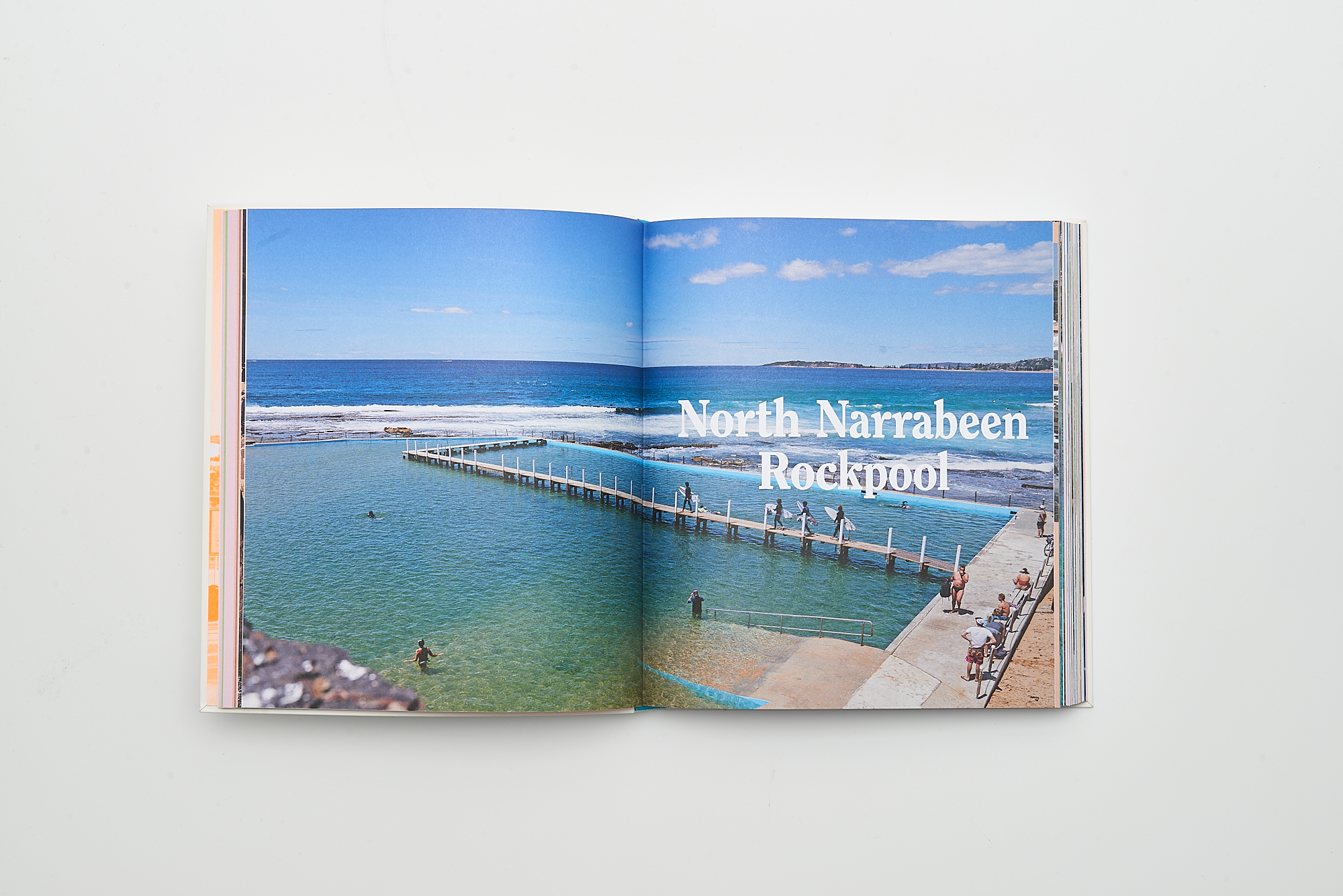
Places We Swim Sydney - A guide to the city for water-loving people.

Places We Swim Sydney features the city’s best beaches, ocean pools, harbour pools, rivers, waterfalls and gorges. We divide the city and its surrounds into six main regions, encompassing walks and swims within two hours of the CBD. You’ll discover just what makes each swimming spot unique, learn the best time to go, and gain some useful local knowledge like where to find the most delicious things to eat nearby.
This is a book for all people that love exploring the outdoors. Whether you are a multi-generational Sydneysider, new resident, or temporary visitor, Places We Swim Sydney will inspire you to experience the city in a new way.
Places We Swim Sydney $42.95


More Stories